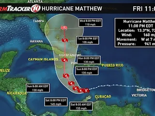
An "extremely dangerous" Category 4 Hurricane Matthew made landfall in Haiti on Tuesday with 145 mph winds and torrential rains, while Florida and North Carolina declared a state of emergency as the storm heads toward the Southeast U.S.
Matthew made landfall near Les Anglais in western Haiti at 7 a.m. Tuesday. The NHC said Matthew, the most powerful Atlantic storm since 2007, will bring life-threatening wind up to 145 mph, surf and rain conditions to Haiti -- the poorest country in the Western Hemisphere beleaguered in recent years by natural disasters like the 2010 earthquake.
Matthew is forecast to track close to Florida's Atlantic coast as a "major" Category 3 hurricane with winds of 120 mph and gusts to 155 mph. Though the state will be on the storm's weakest side, residents should expect tropical storm conditions with strong winds and torrential rains Thursday and Friday.
Computer models continue to shift Matthew's track farther west, making the threat of landfall in the eastern United States a greater possibility. Florida Gov. Rick Scott declared a state of emergency across all counties in the state, while North Carolina Gov. Pat McCrory activated a state of emergency for 66 counties.
Meteorologists warned evacuations in the southeast United States were a possibility.
The U.S. Coast Guard on Monday set conditions that would open Port Miami, Miami River, Port Everglades, Port of Palm Beach, Port of Ft. Pierce and all other South Florida terminals and facilities to commercial traffic.
"Mariners are reminded there are no safe havens in these facilities, and ports are safest when the inventory of vessels is at a minimum," the U.S. Coast Guard said in a statement. "All oceangoing commercial vessels and oceangoing barges greater than 500 gross tons should make plans for departing the port."
The U.S. Coast Guard warns people with boats to make preparations as soon as possible.
The center of Matthew is expected to move near eastern Cuba later in the day, then move over parts of southeastern and central Bahamas Tuesday night and Wednesday -- later approaching the northwestern Bahamas.
Hurricane-force winds extend up to 40 miles from Matthew's center and tropical storm-force winds extend up to 185 miles.
Hurricane warnings were in effect for Haiti; Cuba's Guantanamo, Santiago de Cuba, Holguin, Granma, and Las Tunas provinces; and southeastern, central and northwestern Bahamas. Warnings and watches are expected to be issued for Florida's Atlantic coast Tuesday.
"Matthew is a Category 4 hurricane on the Saffir-Simpson Hurricane Wind Scale," the NHC said in its 8 a.m EST update.
The NHC warns outside hurricane preparation will be difficult or dangerous in Haiti, eastern Cuba and southeastern Bahamas on Tuesday.
Matthew is expected to drop 15-25 inches of rain in southern Haiti and southwestern Dominican Republic, where up to 40 inches of isolated rain could fall. Up to a foot of rain is forecast for eastern Cuba and northwestern Haiti, with up to 20 inches in some areas.
"Life-threatening flash floods and mudslides are likely from this rainfall," the NHC added.
[upi.com]
4/10/16
-
Related:

No comments:
Post a Comment
Only News