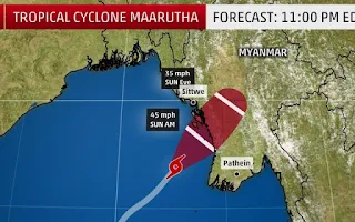
Cyclone Maarutha made landfall on Myanmar's Rakhine coast on Monday night.
It was first classified as a tropical depression on April 15 in the Bay of Bengal, but was never expected to be a major cyclone.
Winds were expected to gust to 100 kilometres per hour and some wind damage was reported in Yangon, but the real risk was always to be from rain.
The cyclone swept the town of Thandwe with steady winds of over 60 km/h and heavy rain, but weakened steadily as it interacted with the rugged terrain of the region. The path taken by the rapidly dissipating cyclone crossed the Irrawaddy river and Naypyitaw.
The coast is rugged and no significant storm surge was forecast. Waves were whipped up by the cyclone but it travelled fairly quickly so they too were not especially big.
Rainfall totals were typically between 100 and 150mm. Pyay, for example, recorded 146mm in 12 hours.
Most rainfall reporting stations are in towns along the Irrawaddy. However, the hills between the major river and the coast are more vulnerable to landslides during this sort of rain.
Maarutha is the first named tropical cyclone in the northern hemisphere this season.
The cyclone season in the Bay of Bengal is typically in two parts: the first precedes the advance of the southwest monsoon and the second, usually more violent, follows the retreat.
Source: Al Jazeera and news agencies
17/4/17

No comments:
Post a Comment
Only News